WinGPS Marine offers you modern, easy to learn navigational tools for a safe trip. Developed for navigation on sailing and motor yachts, sloops and canoes at sea, tidal and inland waters. Ideal when renting or chartering a boat.
Long press on the chart to plot your route. The GPS on board will show your exact location. Download the charts to your device and go boating offline with the most up-to-date charts. Connect your AIS via WIFI, see the other ships with AIS in advance and prevent possible collisions.
Highlights• Offline navigating on up-to-date charts of Stentec, Imray, NOAA and Delius Klasing.
• SD card support for chart storage.
• Create and save routes, tracks and waypoints.
• NOAA World GRIB files: wind, air pressure, rainfall and temperature.
• Connect AIS and GPS wireless via WIFI or Bluetooth.
• Prevent collisions with the speed vectors of the AIS ships.
• Man-overboard button helps to retrieve lost crewmembers.
• Chart moves along underneath centred GPS position. North-up and course-up.
• Support for the waterways for the inland charts of the Netherlands, Belgium, Germany, France, the Baltic Sea and Donau to the Black Sean, with bridge-, locks and waterway information. With this you can plot and adjust your routes quickly, indicating any obstacles. The names of the waterways and distances will be shown during your trip.
• Smart labeling prevents overlapping text labels for an optimal chart image. Bridge and lock data will always be readable on course-up rotating charts.
Detailed screenshotsClick on an image for a larger viewWith the
WinGPS Marine Plus upgrade, you will be able to connect additional board instruments to your WinGPS Marine via wireless connection from you board PC, multiplexer or AIS transponder. You can display currents and tidal information in your data plotter or view it on the chart. Also, the advanced KNMI’s Harmonie weather model is supported as well as the NOAA waves with worldwide coverage and predictions of waves heights and lengths.
KustfijnThe Stentec Tidal Service is a tidal model from Rijkswaterstaat with 2 day wind depended predictions of currents, tides and water levels on the Waddenzee, IJsselmeer, Markermeer, Randmeren and Zeeland. Red depth lines limit the safe waterways depending on depth, tides and deviations because of the wind.
Chart coverage & installing the chartsWhen you start WinGPS Marine you will automatically see the (online) topographic default chart of ESRI. You can also turn on the NOAA charts of the US and download the free world chart via the Chart Manager.
For safe navigation, you can purchase digital charts at
www.stentec.com. It’s also possible to purchase the charts in the app or via Google Play™. Your charts can be installed on 3 different devices. For example, on your Android tablet, phone and Windows laptop or computer.
Log in with your Stentec Account in WinGPS Marine and download or update your purchased DKW2 charts in the Chart Manager.
More information at
wingpsmarine.com.
User inputFor improvement of the app we are very much interested in your experience and suggestions. Please send an e-mail to
helpdesk@stentec.com.
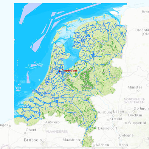
 DKW the Netherlands
The DKW The Netherlands is developed for sailors, motorboaters and commercial use. With its regular updates this chart is
the most up-to-date chart for the inland waterways of the Netherlands.
The DKW Vaarkaart Nederland is great for use with the paid versions of WinGPS. Using the waterway network makes it is very easy to plan routes on the Dutch inland waters.
Chart coverageAll the inland waters in the Netherlands are included in this chart. There are 3 extra detail charts included: the Frisian Lakes, the Biesbosch and the Amsterdam waterways. This chart connects to a.o. the DKW 1800 series, Vaarkaart Northwest Germany, Southwest Germany and Belgium.
Click on the image for a larger viewDetailed screenshotsDepth imageStentec releases this chart annually based on the 'Top10NL-data' from the Dutch topographic services, Inland ENC charts, the Dutch Hydrographic services and user based remarks. This chart contains a large level of detail: with 2 meters per pixel, you can zoom up to the dock at your home port.
WaypointsAll the relevant information is shown on the chart as waypoints. Totally there are 39.019 waypoints for a.o. buoys, marinas, Marrekrite moorings, diesel tank stations, water camp sites, VHF channels, charging stations electric boating and junctions of ‘Varen Doe Je Samen’. Also included are waterway signs and VIN berths for commercial use.