WinGPS Marine Plus offers you modern, easy to learn navigational tools for a safe trip. Developed for navigation on sailing and motor yachts, sloops and canoes at sea, tidal and inland waters. Ideal when renting or chartering a boat.
Long press on the chart to plot your route. The GPS on board will show your exact location. Download the charts to your device and go boating offline with the most up-to-date charts. Connect your AIS via WIFI, see the other ships with AIS in advance and prevent possible collisions.
Highlights• Offline navigating on up-to-date charts of Stentec, Imray, NOAA and Delius Klasing.
• SD card support for chart storage.
• Create and save routes, tracks and waypoints.
• NOAA World GRIB files: wind, air pressure, rainfall and temperature.
• Connect AIS and GPS wireless via WIFI or Bluetooth.
• Prevent collisions with the speed vectors of the AIS ships.
• Man-overboard button helps to retrieve lost crewmembers.
• Chart moves along underneath centred GPS position. North-up and course-up.
• Harmonie model KNMI with detailed weather predictions (Netherlands only).
• NOAA wave prediction at open sea (Worldwide).
• Support for the waterways for the inland charts of the Netherlands, Belgium, Germany, France, the Baltic Sea and Donau to the Black Sean, with bridge-, locks and waterway information. With this you can plot and adjust your routes quickly, indicating any obstacles. The names of the waterways and distances will be shown during your trip.
• Smart labeling prevents overlapping text labels for an optimal chart image. Bridge and lock data will always be readable on course-up rotating charts.
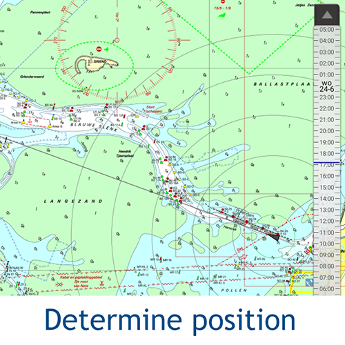
Click on an image for a larger viewDetailed screenshotsKustfijnThe Stentec Tidal Service is a tidal model from Rijkswaterstaat with 2 day wind depended predictions of currents, tides and water levels on the Waddenzee, IJsselmeer, Markermeer, Randmeren and Zeeland. Red depth lines limit the safe waterways depending on depth, tides and deviations because of the wind.
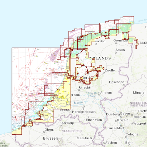
Chart coverage & installing the chartsWhen you start WinGPS Marine you will automatically see the (online) topographic default chart of ESRI. You can also turn on the NOAA charts of the US and download the free world chart via the Chart Manager.
For safe navigation, you can purchase digital charts at
www.stentec.com. It’s also possible to purchase the charts in the app or via Google Play™. Your charts can be installed on 3 different devices. For example, on your Android tablet, phone and Windows laptop or computer.
Log in with your Stentec Account in WinGPS Marine and download or update your purchased DKW2 charts in the Chart Manager.
More information at
wingpsmarine.com.
User inputFor improvement of the app we are very much interested in your experience and suggestions. Please send an e-mail to
helpdesk@stentec.com.
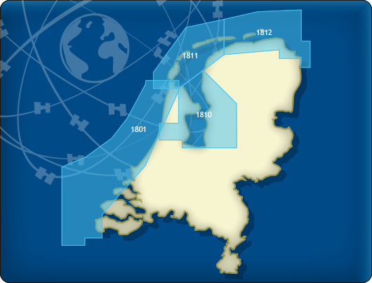 DKW 1800 North
Deze kaartenset geeft u gratis wekelijkse updateservice van de Berichten aan Zeevarenden (BaZ). U heeft de mogelijkheid de kaart op de laptop en tegelijkertijd op een Android-apparaat te gebruiken. Zo kunt u altijd een up-to-date kaart op zak hebben voor deze drukke en veranderlijke wateren. Zodra er een nieuwe papieren kaart wordt uitgegeven door de Dienst de Hydrografie, kunnen licentiehouders van de DKW 1800-serie deze direct in digitale vorm downloaden. Indien gewenst kan de kaart ook worden geprint voor eigen gebruik.
Bij de Waddenzee-kaarten 1811 en 1812 worden de actuele dieptestaten van Rijkswaterstaat meegeleverd. De dieptes worden zowel in NAP als in LAT getoond. Deze dieptestaten worden maandelijkse geüpdatet. Handig voor wadvaarders die een wantij-oversteek willen plannen.
DekkingsgebiedDe volgende DKW1800 series bevinden zich in deze set:
• DKW 1801 Noordzeekust: de Panne tot Den Helder
• DKW 1810 IJsselmeer: Markermeer, Randmeren en Noordzeekanaal
• DKW 1811 Waddenzee West: Waddenzee West en aangrenzende Noordzeekust
• DKW 1812 Waddenzee Oost: Waddenzee Oost en aangrenzende Noordzeekust
Klik op de afbeelding voor een vergrote weergaveDetailafbeeldingen