Stentec’s top navigation software helps you plan the optimal route and therefore provides additional safety at long journeys and extra advantages at regattas. Voyager shows the fastest, shortest, most economical or cheapest route available, both while on engine or under sail.
Not only can you enter the dimensions of your ship, you can also select the polar diagram from a list of over 3000 ships. If your ship is unavailable you can either record your own diagram with WinGPS 6 Voyager and a wind meter or change an existing diagram to the correct data.
With Voyager information on currents and tides is included as well as the option to connect with onboard equipment such as AIS, wind meter, depth meter, autopilot, log and compass.
Download the latest GRIB files for the weather, currents and waves forecast and set your route. Voyager will advise you on the best route, taking the environment and the characteristics of your ship into account.
When the winds are too strong to sail over open water you can easily change the route to inland waterways with the standing mast route. This will give you extra information about bridges & locks and shows how long your new journey will take.
Click on the image for a larger viewDetailed screenshotsMore information:WinGPS navigation software is available for Windows and Android devices which makes it possible to navigate aboard with your laptop, onboard PC, smartphone and tablet. One WinGPS license can be used on two different devices. You are able to plot your routes at home on a desktop PC with a large screen and transfer the data to your onboard device. Another advantage would be to install the software on a second onboard device as backup.
Download GRIB-files for a 7 day weather forecast. During sailing, WinGPS will show your current position, speed and course. Sailed routes will be logged which can be analysed in detail at home or be printed/e-mailed to send to the crew.
 DKW 1800 Complete
This chart set gives you weekly update service, free of charge, with the official ‘messages to mariners’. Also known as the BaZ updates. The charts can be used on a laptop as well as on an Android device. This way you will always have an up-to-date chart of these crowded and unpredictable waters at hand.
As soon as a new paper version of the charts are released by the Dutch Hydrographic Office, users can download these directly in digital form. If desired, the charts can also be printed for personal use.
The Waddenzee charts 1811 and 1812 are supplied with monthly updated depth images from Rijkswaterstaat. These depths are in NAP and LAT. Ideal for trips across the shallow waters on the Waddenzee.
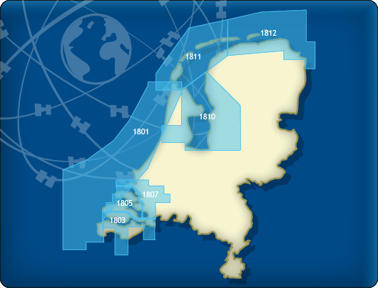
Chart coverageThis set consists of the following DKW 1800 series:
• DKW 1801 North Sea coast: the Panne to Den Helder
• DKW 1803 Westerschelde: Vlissingen to Antwerpen
• DKW 1805 Oosterschelde: Veerse Meer and Grevelingenmeer
• DKW 1807 Zoommeer, Volkerak, Spui, Haringvliet and Hollandsch Diep
• DKW 1810 IJsselmeer: Markermeer, Randmeren and Noordzeekanaal
• DKW 1811 Waddensea West: Waddensea West and adjacent North sea coast.
• DKW 1812 Waddensea East: Waddensea East and adjacent North sea coast.
The DKW 1809 is no longer published by the Hydrographic Service. This chart set covered the area: Nieuwe Waterweg, Nieuwe and Oude Maas, Spui and Noord Dordtsche Kil and the Brielse Meer. You can now use the DKW Vaarkaart Nederland (Complete or South) for this area.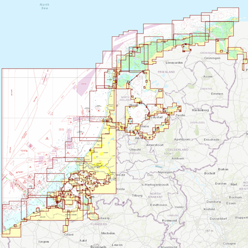
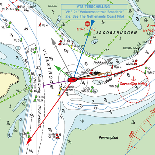
Click on the image for a larger viewDetailed screenshots
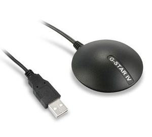 GPS Receiver BU-353 S4
Waterproof sensitive 48 channel GPS receiver with the new SiRF IV chip. With good GPS reception a high accuracy is guaranteed thanks to EGNOS / WAAS support.
With 1.5m USB cable for connection to your laptop. Can be attached magnetically. NMEA-0183 output: GGA, GSA, GSV, RMC, VTG, GLL.
When you have a fiberglass ship, the GPS receiver can be used anywhere on board. If you have a steal ship it is necessary to place the GPS receiver near a window.