By connecting board equipment such as GPS, AIS, compass, wind meter, log, autopilot or depth meter you will turn your laptop or onboard PC into a complete navigational centre. Thanks to the unique AIS extrapolation, passages are planned safer and collisions avoided.
To plan routes over shallow or tidal waters you can use the implemented NLTides database and new Stentec Tidal Service. Enter the sea gauge of your ship, download the latest tidal information and plan your route. WinGPS will instantly tell you where there is enough water under your keel and where your boat might dry out.
When planning a route for several days you will immediately see where you are on the desired resting times allowing you to reserve a suitable spot at a local port. Download the latest ‘messages to mariners’ to avoid any inconvenient blocks along your route.
While sailing your route you can create multiple chart windows. For example, you can use one window to show your ship head-up and another window to show your final destination and your course towards it.
Click on the image for a larger viewDetailed screenshotsMore information:WinGPS navigation software is available for Windows and Android devices which makes it possible to navigate aboard with your laptop, onboard PC, smartphone and tablet. One WinGPS license can be used on two different devices. You are able to plot your routes at home on a desktop PC with a large screen and transfer the data to your onboard device. Another advantage would be to install the software on a second onboard device as backup.
Download GRIB-files for a 7 day weather forecast. During sailing, WinGPS will show your current position, speed and course. Sailed routes will be logged which can be analysed in detail at home or be printed/e-mailed to send to the crew.
For the windsailing fanatics WinGPS 6 Voyager is the option to go for. Choose your ship’s polar diagram from an extensive list and receive the optimal sailing route automatically.
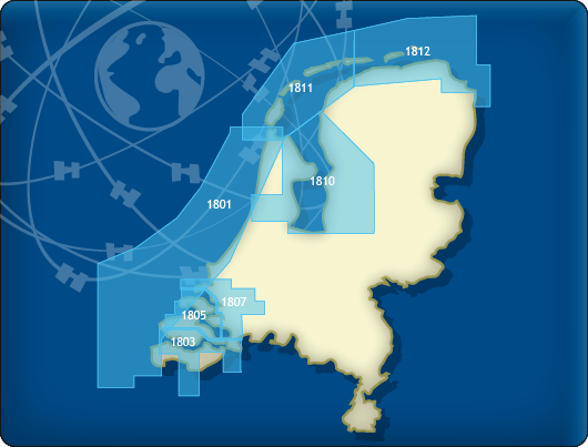 DKW 1800 Complete
This chart set gives you weekly update service, free of charge, with the official ‘messages to mariners’. Also known as the BaZ updates. The charts can be used on a laptop as well as on an Android device. This way you will always have an up-to-date chart of these crowded and unpredictable waters at hand.
As soon as a new paper version of the charts are released by the Dutch Hydrographic Office, users can download these directly in digital form. If desired, the charts can also be printed for personal use.
The Waddenzee charts 1811 and 1812 are supplied with monthly updated depth images from Rijkswaterstaat. These depths are in NAP and LAT. Ideal for trips across the shallow waters on the Waddenzee.
Chart coverageThis set consists of the following DKW 1800 series:
• DKW 1801 North Sea coast: the Panne to Den Helder
• DKW 1803 Westerschelde: Vlissingen to Antwerpen
• DKW 1805 Oosterschelde: Veerse Meer and Grevelingenmeer
• DKW 1807 Zoommeer, Volkerak, Spui, Haringvliet and Hollandsch Diep
• DKW 1810 IJsselmeer: Markermeer, Randmeren and Noordzeekanaal
• DKW 1811 Waddensea West: Waddensea West and adjacent North sea coast.
• DKW 1812 Waddensea East: Waddensea East and adjacent North sea coast.
The DKW 1809 is no longer published by the Hydrographic Service. This chart set covered the area: Nieuwe Waterweg, Nieuwe and Oude Maas, Spui and Noord Dordtsche Kil and the Brielse Meer. You can now use the DKW Vaarkaart Nederland (Complete or South) for this area.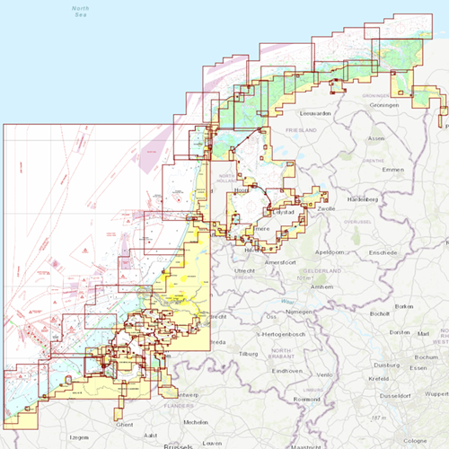
Click on the image for a larger viewDetailed screenshots
 DKW the Netherlands
The DKW The Netherlands is developed for sailors, motorboaters and commercial use. With its regular updates this chart is
the most up-to-date chart for the inland waterways of the Netherlands.
The DKW Vaarkaart Nederland is great for use with the paid versions of WinGPS. Using the waterway network makes it is very easy to plan routes on the Dutch inland waters.
Chart coverageAll the inland waters in the Netherlands are included in this chart. There are 3 extra detail charts included: the Frisian Lakes, the Biesbosch and the Amsterdam waterways. This chart connects to a.o. the DKW 1800 series, Vaarkaart Northwest Germany, Southwest Germany and Belgium.
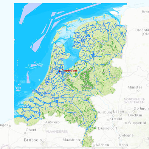
Click on the image for a larger viewDetailed screenshotsDepth imageStentec releases this chart annually based on the 'Top10NL-data' from the Dutch topographic services, Inland ENC charts, the Dutch Hydrographic services and user based remarks. This chart contains a large level of detail: with 2 meters per pixel, you can zoom up to the dock at your home port.
WaypointsAll the relevant information is shown on the chart as waypoints. Totally there are 39.019 waypoints for a.o. buoys, marinas, Marrekrite moorings, diesel tank stations, water camp sites, VHF channels, charging stations electric boating and junctions of ‘Varen Doe Je Samen’. Also included are waterway signs and VIN berths for commercial use.


