With the DKW 1800 Series North, you have an up-to-date and reliable set of digital charts for the Dutch coastal waters, including the trusted
weekly NtM (BaZ) updates that are automatically installed in WinGPS.
Thanks to the option to use the chart on both your laptop and Android device, you always have the most recent information at hand while underway.
For the Wadden Sea charts 1811 and 1812, the current
depth tables from Rijkswaterstaat are included. Depths are shown in both NAP and LAT, and the depth tables are updated monthly. Ideal for sailors planning a tidal flat crossing.
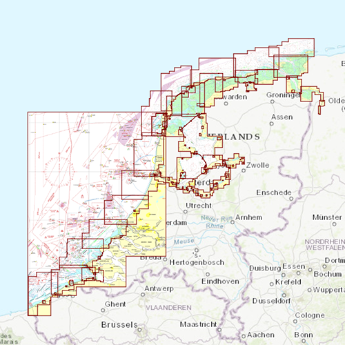
Chart coverageThis set consists of the following DKW 1800 series:
• DKW 1820 IJsselmeer: Markermeer, Ketelmeer and Noordzeekanaal
• DKW 1811 Waddensea West: Waddensea West and adjacent North sea coast.
• DKW 1812 Waddensea East: Waddensea East and adjacent North sea coast.
Click on the image for a larger viewDetailed screenshotsWind and currentsThis chart is perfect in combination with WinGPS Pro, WinGPS Voyager and/or WinGPS Marine+. You can easily download the current wind and currents data, for safe route planning.
More information:
The DKW charts are compatible with both WinGPS 5 and 6 (for Windows), WinGPS Marine (for Android and iOS) and WinGPS Yacht Navigator (for Windows, Android and iOS). A DKW Chart can be used on 3 devices simultaneously.