Stentec Navigation
Inloggen
en
de
nl
Home
Shop
Contact
Your details
Commercial Shipping
Search results
subscriptions
subscriptions
dkw-coastal-waters-NL
Home / Shop
Find a product
search
Stentec Shop
Navigation Software
Digital Charts
DKW Coastal waters NL
DKW Inland
DKW International
DKW Imray
DKW Delius Klasing
NV-Verlag
Commercial shipping
Hardware
Pilots & Charts
Books
Simulation Software
back to overview
DKW International
Detailed digital charts for water sports and professional inland navigation, specifically for use with WinGPS navigation software.
Click on a chart area for a direct link to the chart set in our webshop.
All chart sets in this series:
Art.nr.
:
All
3209
5001
5002
5003
5004
5005
5006
5007
5008
5009
5010
5011
5012
5013
5014
5021
5022
5023
5051
5052
5053
5054
5055
5056
5057
5058
5059
6223
6224
6225
6226
6227
6228
6231
6232
6233
6234
6236
6237
6238
6239
6240
6303
6304
6305
6306
6307
6308
6310
6311
6312
6313
6321
6322
6323
6330
6331
6335
6336
6355
6356
6357
6358
6481
6482
6483
6484
6485
6500
6501
6502
6503
6514
6551
6552
6553
6554
6555
6556
6573
6574
6575
6585
6591
6592
6593
6594
6595
6596
6597
6598
7203
7204
7207
7208
7209
7210
7211
7212
7213
7214
7215
7216
7221
7225
7227
7260
7261
7262
7263
7267
7268
7269
7273
7285
7410
7411
7420
7421
7430
7434
7435
7438
7450
7451
7460
7461
7465
7466
7470
7471
7472
7473
7474
7475
7480
7482
7484
7701
7702
7703
7704
7705
7706
7707
7710
7711
7712
7713
7714
7715
7716
7717
7720
9303
9304
9305
9306
9307
9308
9310
9311
9323
9324
9332
9333
keyword:
search
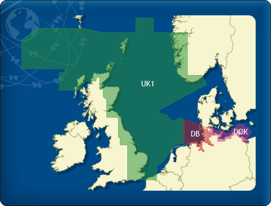
DKW UK1 English & Scottish East Coast
DKW UK1 Engelse & Schotse Oostkust
For Northsea and England sailors.
With more details than the ID10, a.o. the Thames past London until Teddington.
Region
North Sea
Edition
2026
Chart for
Available as
Download
Price from
€ 139,90
More info / Order
more info
DKW German Bight
DKW Duitse Bocht
Digital chart set with free weekly updates.
Perfect fit to DKW 1812.
Region
North Sea
Edition
2026
Chart for
Available as
Download
Price from
€ 129,90
More info / Order
more info
DKW German Baltic coast
DKW Duitse Oostzeekust
Perfect fit to DKW German Bight.
Region
Baltic Sea
Edition
2026
Chart for
Available as
Download
Price from
€ 109,90
More info / Order
more info
DKW Vaarkaart Suriname
DKW Vaarkaart Suriname
Coast of Suriname, including overview chart and lower reaches of the Corantijn and Suriname rivers.
Region
Caribbean and America
Edition
2026
Chart for
Available as
Download
Price from
€ 99,90
More info / Order
more info
1 - 4
shopping cart
basket is empty
view basket
We accept the following payments:
Login
email address
Password
Login
You forgot your password?