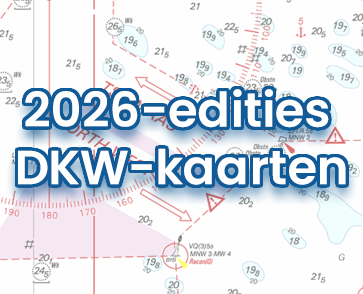
With our new DKW 1600+, you can navigate the Dutch and Belgian coasts with a clear, up-to-date digital chart, including the trusted weekly BaZ updates automatically installed in WinGPS.
The chart is based on the Hydrographic Chart 1600 and supplemented with additional chart sheets. This gives you a single, clear overview of the most important sailing areas along the coast and in the North Sea.
NEW: This new digital chart offers extra-wide North Sea coverage and smart alert zones for enhanced safety near wind farms and other locations. Coverage AreaThe DKW 1600+ covers:
•
the North Sea coast of the Netherlands and Belgium:
In some areas, up to 85 miles from the coast. This includes the numerous wind farms and traffic separation schemes.
•
the Rijnmond area:
This includes the Maasvlakte up to Capelle aan den IJssel, Lekkerkerk, Sliedrecht, 's Gravendeel up to Oud Beijerland.
•
the Westerschelde up to Antwerp and Ghent..
The DKW 1600+ is the ideal replacement for the well-known 1801 North Sea Coast, 1803 Western Scheldt, and 1809 Rijnmond areas, which are no longer published by the Hydrographic Service. It is ideal for combining with the DKW 1800 Complete series. This creates a beautiful set of up-to-date charts for Dutch coastal waters.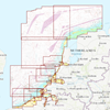
Click on the image for a larger viewDetailed screenshots•
Based on Hydrographic Chart 1600:
Clear, well-organized chart display, just like you're used to from the paper 1600, available digitally in WinGPS.
•
Extensive North Sea Coverage:
The DKW 1600+ covers much further North Sea than you're used to with traditional coastal charts. Ideal for coastal voyages, crossing between North Sea ports, and planning routes along the Dutch and Belgian coasts.
•
Includes Weekly Notices to Mariners (NtM) Updates:
The chart is updated weekly with the latest Notices to Mariners (NtM). These updates are automatically installed via WinGPS, ensuring your charts are always up-to-date.
•
A Practical Replacement for Discontinued 1800 Charts:
Because several 1800 charts are no longer published by the Hydrographic Service, many users were looking for a suitable alternative. The DKW 1600+ offers a practical successor for these sailing areas, with comparable coverage, BaZ updates, and a familiar chart view in your WinGPS navigation system.
•
Includes innovative alarm zones:
Preset alarm zones for wind farms, among others, for easily planning safe routes and which warn you in WinGPS 6 as soon as you approach a risk area.
Wind and currentsThis chart is perfect in combination with WinGPS Pro, WinGPS Voyager and/or WinGPS Marine+. You can easily download the current wind and currents data, for safe route planning.
More information:
The DKW 1600+ can be used in WinGPS 5 and 6 (for Windows), in WinGPS Marine (for Android and iOS), and in WinGPS Yacht Navigator (Windows, Android, and iOS).
The included alarm zones can only be used in WinGPS 6 Pro, Voyager, or Inland from the 2026 edition or newer.
A DKW chart can be used on up to three devices simultaneously.