https://www.stentec.com/shop/images/dkw/nieuw/DKW1600+1800-NIEUW.png

DKW 1600/1800 Complete

Digital chart set with free weekly BaZ updates
New!
  
Chart for:  
Medium:  Download
Delivery:  Direct download
  
Price:  € 199,90
 
With this combination package, you have the most complete digital chart set for the Dutch coastal waters. The DKW 1600+ and the DKW 1800 Series Complete connect seamlessly and together offer a clear and reliable overview of all major sailing areas: from the Belgian coast to the IJsselmeer, the Wadden Sea and far out onto the North Sea.

The weekly Notices to Mariners (NtM/BaZ) are automatically installed in WinGPS, ensuring you always sail with the latest information on buoyage, depths, wind farms and waterway changes.

Thanks to support for both Windows (WinGPS 5/6) and Android (WinGPS Marine), you always have an up-to-date chart available on any device.
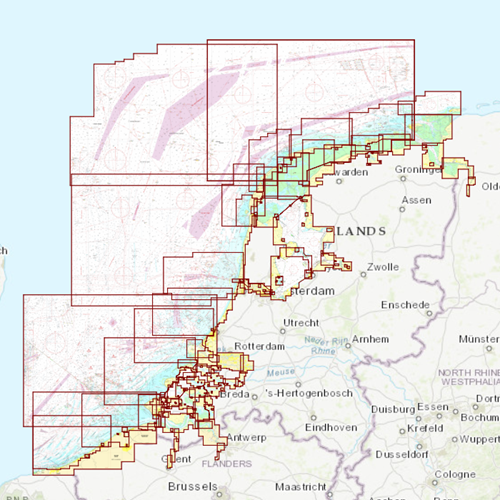
 Coverage & Benefits

DKW 1600+
• Clear coastal charts of the Netherlands and Belgium
• Extra wide North Sea coverage, up to 85 miles offshore
• The Rhine?Meuse delta (Rijnmond area)
• The Westerschelde Western Scheldt up to Antwerp and Ghent
• Includes innovative alarm zones for restricted areas such as traffic separation schemes and wind farms
• Replacement for the discontinued DKW 1801, 1803 and 1809 charts

DKW 1800 Series Complete
• DKW 1805 and 1807: Oosterschelde, Grevelingen, Haringvliet, Hollandsch Diep
• DKW 1820: IJsselmeer, Markermeer, Ketelmeer, North Sea Canal
• DKW 1811 and 1812: Western & Eastern Wadden Sea, incl. adjacent North Sea coast
• Includes monthly Rijkswaterstaat depth tables (NAP/LAT) for 1811 & 1812
With this combination package, you have one complete, up-to-date and user-friendly overview for all Dutch coastal and inland waters. Ideal for both recreational and professional navigation.


Click on the image for a larger view


Detailed screenshots


Wind and currents
This chart is perfect in combination with WinGPS Pro, WinGPS Voyager and/or WinGPS Marine+. You can easily download the current wind and currents data, for safe route planning.
More information:  
The DKW 1600+ and DKW 1800 Series can be used in WinGPS 5 and 6 (for Windows), in WinGPS Marine (for Android and iOS), and in WinGPS Yacht Navigator (Windows, Android and iOS).
The alarm zones included with the DKW 1600+ can only be used in WinGPS 6 Navigator, Pro, Voyager or Inland (2025 edition or newer).
A DKW chart can be used on up to 3 devices simultaneously.

Productspecifications

Art.nr.:  7227
Producer:  Dienst der Hydrografie, UKHO, BSH
Publisher:  Stentec Software
Languages:  Dutch
Region:  Coastal waters the Netherlands
Edition:  2026
System Requirements:  Official version of WinGPS 4/5/6, WinGPS Marine or WinGPS Yacht Navigator.
335MB disk space.

Order your DKW charts now for 2026

For example our new DKW 1600+ North Sea Coast NL, or the popular DKW 1800 series and DKW The Netherlands!


Premium Subscription 2026

Receive the latest WinGPS 6 in 2026 with all updates, exclusive discounts and premium helpdesk service.


Navigate with the newest WinGPS 6

Navigate smarter, faster and safer with the latest edition of WinGPS. Discover the renewed Routeplanner 2.0, the new BASIC Mode and many more improvements.

Start using WinGPS 6 today and you're
up-to-date until 2027!


Navigate carefree with an up-to-date system on board!
Updated charts and navigation software help you in your travels. Do you already have your onboard navigation system ready? Update your WinGPS and charts now, or contact us. We are happy to think along with you about what you need for your upcoming trips.


Do you have any questions?

Call us on +31 515 443515, fill in the contact form or make an appointment at our store in Heeg.

shopping cart
basket is empty
view basket