Pilots & charts

In addition to digital, we recommend also having paper charts on board:

-The Delius Klasing paper charts now also include a digital chart in DKW format, which can be used free of charge for 1 year.

-The paper charts from Imray provide a nice backup for all your trips on our DKW charts from Imray, so you have the same chart image in front of you during the trips.

-The paper charts from NV-Verlag also contain a digital chart. You can also load this into WinGPS 6 for Windows and use it for navigation.

-A pilot is indispensable on board. All marinas are described in detail as well as all port information, shopping, and dining facilities.

https://www.stentec.com/shop/images/dkw/dkw1800compleet.png

DKW 1800 Complete

Digital chart set with free weekly BaZ updates
  
Format:  
2024
Chart for:  
Medium:  Download
Upgrade from:  -
Delivery:  Direct download
  
Price:  € 139,90
 
This chart set gives you weekly update service, free of charge, with the official ‘messages to mariners’. Also known as the BaZ updates. The charts can be used on a laptop as well as on an Android device. This way you will always have an up-to-date chart of these crowded and unpredictable waters at hand.

As soon as a new paper version of the charts are released by the Dutch Hydrographic Office, users can download these directly in digital form. If desired, the charts can also be printed for personal use.

The Waddenzee charts 1811 and 1812 are supplied with monthly updated depth images from Rijkswaterstaat. These depths are in NAP and LAT. Ideal for trips across the shallow waters on the Waddenzee.

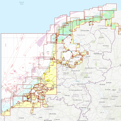
Chart coverage
This set consists of the following DKW 1800 series:

• DKW 1801 North Sea coast: the Panne to Den Helder
• DKW 1803 Westerschelde: Vlissingen to Antwerpen
• DKW 1805 Oosterschelde: Veerse Meer and Grevelingenmeer
• DKW 1807 Zoommeer, Volkerak, Spui, Haringvliet and Hollandsch Diep
• DKW 1810 IJsselmeer: Markermeer, Randmeren and Noordzeekanaal
• DKW 1811 Waddensea West: Waddensea West and adjacent North sea coast.
• DKW 1812 Waddensea East: Waddensea East and adjacent North sea coast.

The DKW 1809 is no longer published by the Hydrographic Service. This chart set covered the area: Nieuwe Waterweg, Nieuwe and Oude Maas, Spui and Noord Dordtsche Kil and the Brielse Meer. You can now use the DKW Vaarkaart Nederland (Complete or South) for this area.


Click on the image for a larger view


Detailed screenshots


Wind and currents
This chart is perfect in combination with WinGPS Pro, WinGPS Voyager and/or WinGPS Marine+. You can easily download the current wind and currents data, for safe route planning.
More information:  
The DKW charts are compatible with both WinGPS 5 and 6 (for Windows), WinGPS Marine (for Android and iOS) and WinGPS Yacht Navigator (for Windows, Android and iOS). A DKW Chart can be used on 3 devices simultaneously.

Productspecifications

Art.nr.:  7209
Producer:  Dienst der Hydrografie, UKHO, BSH
Publisher:  Stentec Software
Languages:  Dutch
Region:  Coastal waters the Netherlands
Edition:  2024
System Requirements:  Official version of WinGPS 4/5/6 or WinGPS Marine.
340MB disk space.

document.addEventListener("DOMContentLoaded", invisiblediv); function invisiblediv() { url_var = window.location.href; if ( url_var != "https://shop-en.stentec.com/pilots--and--charts/p-1a-2/" && url_var != "https://shop-en.stentec.com/pilots--and--charts/p-1a-2/?cid=1" && url_var != "https://shop-en.stentec.com/pilots--and--charts/p-1a-2/?cid=2" && url_var != "https://shop-en.stentec.com/pilots--and--charts/p-1a-2/?cid=3" && url_var != "https://shop-en.stentec.com/pilots--and--charts/p-1a-2/?cid=4") document.getElementById("productblok").style.display = "none"; }
shopping cart
basket is empty
view basket